Note: I joined Epic Backpacker Tours for this 2021 trip to Pakistan.
Our group’s itinerary in Pakistan is roughly divided into 2 sections: visiting Fairy Meadows as a warm up and to acclimatize before heading out for a 3 day 2 night trek to Moses Peak.
However, a major landslide that happened on our 2nd day in Pakistan threw a wrench into the plan. Not only did it cause us to be stuck on the road for 4 hours, waiting for the military to clear the highway, the notoriously steep road to Fairy Meadows was also destroyed. A popular destination for local and foreign tourists alike, they were working non stop to clear the road, but still… it wasn’t going to happen in time.
So our leader made the call to flip the itinerary into one where we visited Fairy Meadows at the end of our visit in Pakistan. The hope was to give more time for the crew to clear the road. Even then Fairy Meadow almost didn’t happen, and there was talk of scrapping it off the itinerary altogether. I’m so glad we were able to make it happen.
Where and what is Fairy Meadow
How to get to Fairy Meadow
Step 1: Get to Gilgit. From Islamabad, the easiest option is to fly. Second easiest to get a shared taxi, your hotel in Islamabad might be able to point you in the right direction.
Step 2: Get to Raikot Bridge. A taxi from Gilgit should take about 2 hours – Insha Allah.
Step 3: Take a jeep ride (8000 Rp as in 2021) from Raikot Bridge to a village called Tatu.
Step 4: From Tatu Village, either hike or take a horse to Fairy Meadows proper.
Fairy Meadows is a high altitude, alpine meadow located in Rakhiot valley at the end of a glacier by the same name. It’s a popular destination for local and foreign tourists, I’d say it’s a must visit for any Pakistan itinerary. The grassland was given the name Märchenwiese (literally “Fairy Tale Meadows”) by German mountaineers who were no doubt astounded when they first glimpsed this idyllic landscape.
At over 10000 ft above sea level, the meadow lies in the shadow of Nanga Parbat, the second-highest mountain in Pakistan after K2, that towers over Fairy Meadows from the south.
The Jeep Road


What makes the place special isn’t only its spectacular location, but the dangerous road one must take in order to get here. The fifteen kilometer-long jeepable trek starting from Raikot Bridge on Karakoram Highway is open to locals only. They ferry tourists one jeep-load at a time – at what seemingly neck-breaking speed – from Raikot bridge to the village called Tato where the jeep track ends.
The dirt road is flanked by a rock wall on one side, and a steep drop off on the other. I was told – which I found hard to believe – that the road used to be even narrower! Accidents do happen and there was a spot where you can see remnants of a jeep down below, victim of a careless – and I assumed speeding – driver.

The jeep road and the surrounding landscape

A week after the landslide, the road still wasn’t completely cleared so we had the hike a stretch of the jeep road before getting picked up on the other side of the landslide. It was a steep, dusty, and hot hike. We had to navigate across parts of the road that were washed away. We saw workers clearing landslide debris under dangerous work conditions (OSHA would have had a heart attack) and rebuilding the retaining wall by hand, one rock at a time.

Navigating the washed up trail

In Tato, where the jeep dropped us off, there’s some sort of a tea house here where you can get some food and drink (and bathrooms!). From here it’s still a 3.1 mile hike to Fairy Meadow proper. Or you can hire a horse. Guess which one I opted for?

Tato Village, from here it’s another 3 mile hike to Fairy Meadow. Horses are available for hire from here.

Fairy Meadows
With the snow-covered giant peak of Nanga Prabat looming above Fairy Meadows is spectacular. A great place to chill and watch the sunset over the peak of Nanga Prabat, and watching locals playing cricket.
Fairy Meadows is quite developed by Pakistani standard. The site serves as a launching point for mountain climbers summiting the northern face of the Nanga Parbat. There are guesthouses and shops, although they seemed to be either under construction or have random opening hours.


Looking at Nanga Parbat over the meadow


Fairy Meadow

Sunset over Fairy Meadow
Our group stayed at Fairy Meadow Greenland Resort which sounds fancier that it actually is. But I was happy to have my own cabin and bathroom. Besides, with the views around I’d have been happy with much, much less.
In the evening of the day we arrived, we explored the meadow trying to find the best vantage point to see the sunset. Even though we didn’t see other foreigners at the time, the place was bustling.
Fairy Meadow seems to be a popular domestic destination for city dwellers looking to escape the sweltering heat in the cities. In fact, later on that night we were invited by some local Pakistani city folks to join them for grilled skewers over bonfire. This type of interaction is often a little awkward for me because of language barrier – as was the case here, but I will always say yes to such invites. For someone who forgets things easily, I tend to remember these moments the best.
Some people in our group had the stomach bug and were unable to join in on activities. Pakistan seems to be the kind of country where someone in your group is almost guaranteed to be recovering from something: either a bad meal, or altitude sickness, or heatstroke…
It’s unfortunate because our hike to Nanga Parbat basecamp the next day was something special.
Hiking to Nanga Parbat basecamp
Length: 10.2 mile round trip
Difficulty: difficult
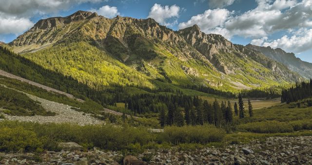
The hike from Fairy Meadow to the Nanga Parbat basecamp took us past a village so beautiful I almost wished we had stayed there instead. It consisted of neat wooden houses surrounded by vegetable gardens and corrals for livestock. The peak Nanga Prabat dominates the sky like a white-shrouded protector. The locals were friendly but also very strict about not allowing photography of the women and children.


The small village along the way to the basecamp. There’s a little guesthouse/tea house on its outskirt where we stopped to filter water and later for food on our way back.
Note: if Fairy Meadow is too crowded for you, Beyal Camp near this village is an alternative camping place. You can hike to Beyal Camp from Fairy Meadows and it takes almost 2-3 hrs.
We continued past the village and it starts to get really steep. And at that elevation? Oh boy. I was going slow, slow, slow. I kept telling myself to just take it one step at a time.
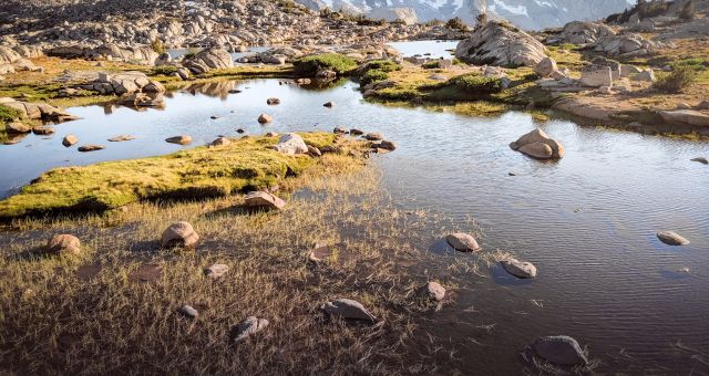
Then the trail meanders along wildflower dotted fields, but always up, and up. I couldn’t NOT stop and take pictures every 10 steps, it was so astoundingly gorgeous (also, I needed the rest, lol). And even though I could barely get any oxygen into the lungs, I was having the most amazing time. In the meantime the bulking mass of Nanga Prabat was gradually overtaking our field of vision. It was such a massive mountain. It made Colorado 14’ers seem like puny hills by comparison.


We had to cross a moraine field, so loose that we could hear and see rocks – from pebbles to bowling bowl sized – sliding all around us. It felt like one wrong step could bring a hill of rocks and sand down on us. We tried to move quickly as we could. Once we were through the morraine field we finally spotted our destination, a small teahouse made of stones on top of a ridge.
We ended the hike at a teahouse at the Nanga Parbat Base Camp. I was looking forward to having snacks. Our guide kept telling us, “we’re almost there then we’ll have tea”. Looking back, I think he was just saying that to keep us going. Based on what I saw at Fairy Meadow where all the tuckshops seemed to have random opening hours, I was skeptical it would be open. Well, guess what? It was closed.
Oh well. I didn’t come here for tea after all, I came for the mountain. And what a mountain it was!

Vibe: Wildflower and glacier covered peaks

The teahouse at the Nanga Parbat basecamp

Me in front of the closed-for-the-season teashop. Empty stomach but full heart.
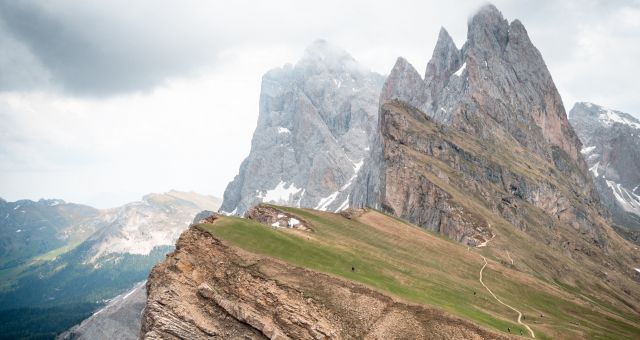
Nanga Parbat is the second highest mountain in Pakistan after K2. At 8,126 m (26,660 ft) it’s the world’s 9th highest. It is huge, majestic, and an impressive sight to behold close up. It is known to be notoriously difficult and dangerous to climb. It has claimed the lives of many mountaineers over the years, leading to its nickname: the Killer Mountain.
Here at the base camp, the 8000+ m mountain filled my entire vision. My jaw dropped and my eyes were as big as saucers. You’ll inevitably feel small and insignificant. I understand why people in the old days (and even now), believe that Gods reside on top of these mountain peaks. It was terrifying, it was beautiful, and it was magnificent.

Questions and Comments
Comments are disabled. If you have any questions about the post, you can DM me on Instagram: @jacknjilltravel.