The Tugela Gorge is the 2nd most popular hike in Royal Natal National Park, South Africa – after, and not to be confused with, Tugela Falls hike. This post will tell you everything you need to know about hiking the Thukela Gorge trail on your own. I did this hike a couple of days after completing the hike to Tugela Falls and found it be tougher mentally. Even though the trail was mostly flat, it was longer, very overgrown, and muddy after the rain.
The Details
Overview of the Hike: 14km roundtrip
Location: Royal Natal National Park
Trailhead: The Gorge parking lot (follow direction to Thendele camp)
Highest Point: 3254 m
Elevation Gain: 700 m
Time to do the hike: 5-6 hrs
Difficulty: moderate (boulder hopping, wading fast knee-deep water, chain ladders, uneven/muddy terrain).
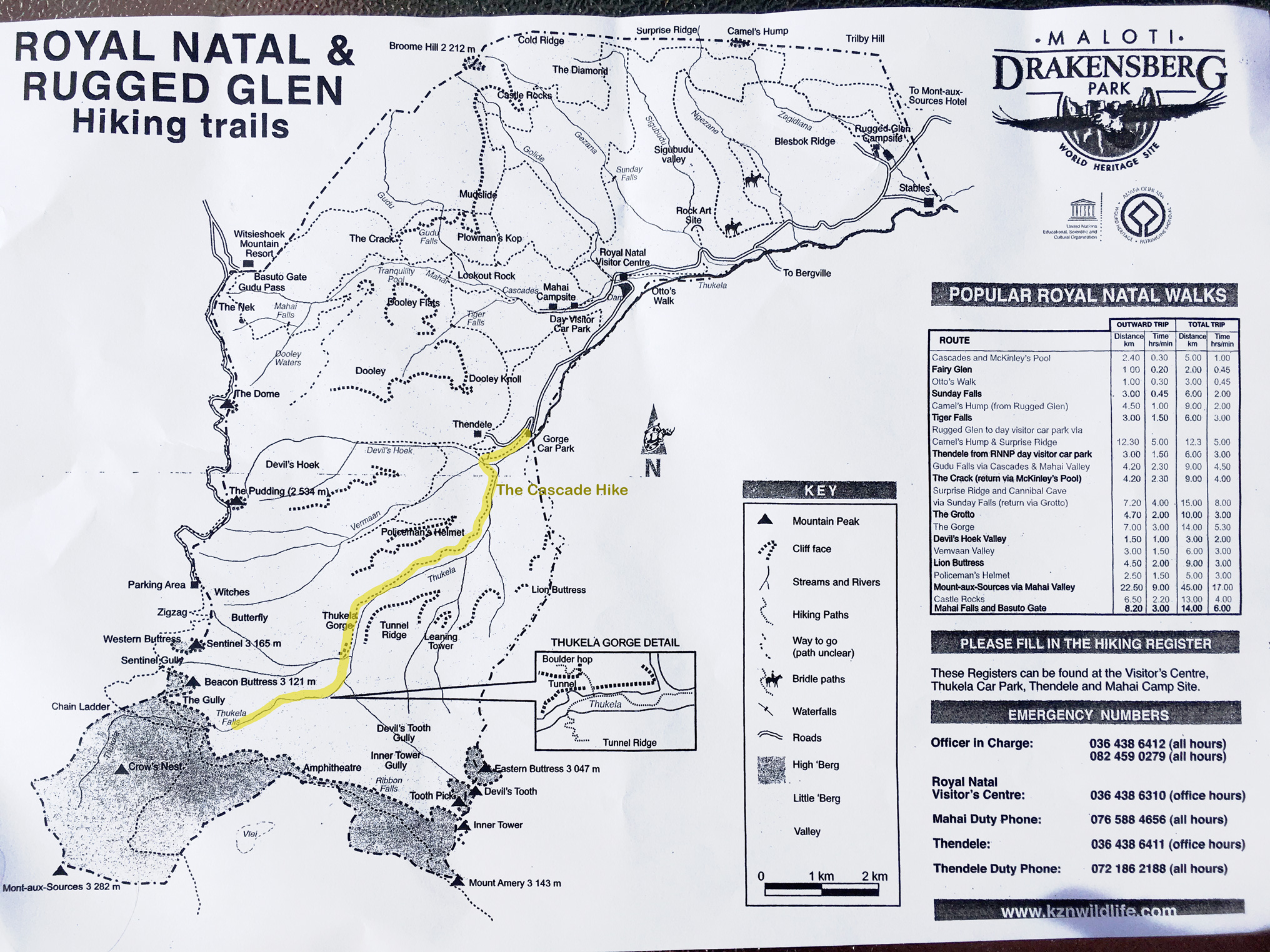
Tugela Gorge Hike
Thukela (Tugela) Gorge Hike
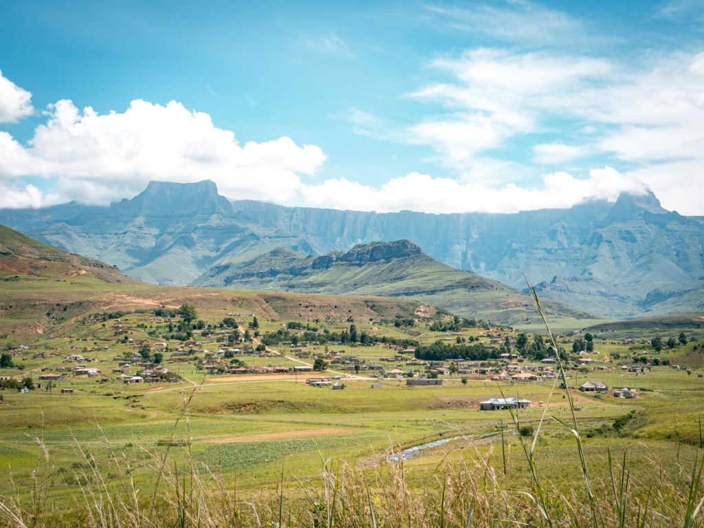
Both the Amphitheatre and the Cascade Hike are located in Royal Natal National Park in South Africa, about 4 hour drive from Durban. The park is known for the striking rock wall called the Amphitheater, stretching 5 km end to end and over 1000 m in height.
There are 2 hikes associated with this impressive formation:
- The famous Amphitheatre/Tugela Falls hike takes you to the top of the formation where Tugela Falls starts its plunge. This post.
- The Tugela Gorge trail (this post) takes you to the bottom of the Tugela Falls. At the end of this hike, you’ll be looking up at the amphitheater’s imposing wall.
I consider these 2 hikes to be the best hikes in Royal Natal. If you only have time to do 1 hike though, I highly recommend the Amphitheatre/Tugela Falls Hike. It firmly belongs in my top 10 all-time favorite day hikes.


Tugela Gorge: The Hike
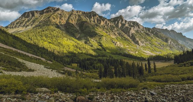
I started the hike from the car park on the way to Thendele camp. The first part of the hike is paved but it quickly became a narrow dirt path as it makes its way through the Thukela Valley’s lush landscape. The trail would’ve been obvious if it weren’t so overgrown. When I was there, parts of the trail were so overgrown I was getting worried that the trail was no longer maintained.
The trail was extremely muddy and the foliage wet from the rain the night before. The front of my pants quickly became soaked from the overgrown foliage brushing against them. To be honest, it wasn’t the most enjoyable hike I’d ever done having to watch my step all the time, in soggy pants, and with a threat of upcoming rain overhead. But I persisted.
The first landmark you’ll come across, after about 4km, is a rock formation called the Policeman’s Helmet, visible on a high ridge on your right hand side.
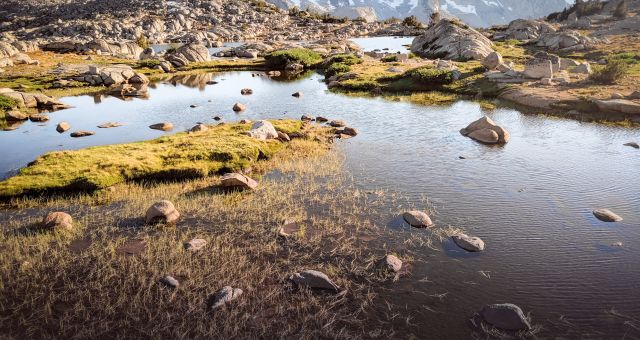
After 6 km of wet bush whacking (misery level: high), the trail ends at the mouth of the narrow, steep-sided Tugela River gorge. In summertime I imagine that this would make a great resting area where you can jump in the river to cool off. But alas, here it started raining on me. I continued making my way along the river, criss-crossing the river whenever I got stuck.

See how the walls converge on the foreground? That’s where the gorge is.

The Tunnel
A short walk along the river bed brought me to a ladder, climbing the right wall of the gorge. The ladder marked the beginning of the section of the hike often referred to as “The Tunnel”, the point where the gorge narrows so much it forms some sort of a tunnel.

Left: The Beginning of the gorge. Right: The Tunnel at low water level (credit)
Unfortunately the ladder bore a “Do Not Climb – Under Repair” sign attached. Ugh. The sign posed a problem. If the water level had been low, I could wade through The Tunnel until the gorge opens out again. This wasn’t the case when I was there. The river was full and fast, and I was slightly worried about going through narrow tunnel by myself. Alternatively, I could use the ladder to bypass the tunnel. But what about the warning sign? With a sigh, I tested the chains, I put my weight on the lowest rung and jumped on it multiple times. Seemed solid enough. Up I went.
After surviving the ladder climb, I climbed through tangled tree roots, pulled on dodgy cables, and crawled underneath overgrown bushes only to find myself back down by the river at small break in the middle of the tunnel. It seems that even though I managed to bypass the main section of the tunnel, there’s still some very narrow section I still had to go through.
The water level here was still at least waist high and it was still flowing fast. It was all very intimidating. I hesitated. I have been on many solo hikes, but rarely did I ever turn back regardless of weather or trail condition. At this point though I was wet, muddy, and simply just sick of the trail.
Through the misty rain I could see Tugela Falls ahead of me. The end of the gorge where awaits just beyond, but looking at churning water out of the dark, narrow tunnel opening… I decided that I wasn’t stupid/brave enough to do this and turned around. Let me tell you, turning around wasn’t an easy decision. But between the weather, the lack of cellphone signal, and the fact that I was on my own, it was simply the smart decision.
Related: 2 Week South Africa Itinerary


Moody
Notes on Hiking Tugela Gorge
- If you’re planning to do more hikes in Drakensberg, I recommend this Cicerone guide. They make the best hiking guides.
- Maps.me app has trails for the area as well and it’s available for free offline.
- Lightweight drybag – this never left my daypack while in South Africa.
- Check the weather forecast before setting off. Heavy rain may cause flash floods.
Where to Stay
Ledges Retreat: 30 minute drive from the trailhead. Breakfast included and dinner is available to order. Newly renovated lodging in a beautiful setting.


Questions and Comments
Comments are disabled. If you have any questions about the post, you can DM me on Instagram: @jacknjilltravel.